|
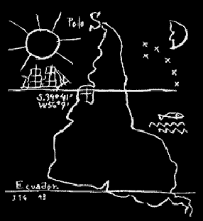
This is a famous illustration of South America by the Uruguayan modernist Joaquín Torres-García, often called the Upside-down Map (1943). This may have been one of the first of these kinds of maps.
This illustration became a centerpiece in the history of Latin American efforts at reclaiming themselves in a world vision. Torres-García placed the South Pole at the top of the earth, thereby suggesting a visual affirmation of the importance of the continent, and in an effort to present a pure revision of the world. He was also interested in presenting to the world a modern "school of the south," a place of experimentation that could rival what was happening in Paris or New York.
For more information on this, see an article by Yasmin Ramirez at the New York Foundation for the Arts.
|
|