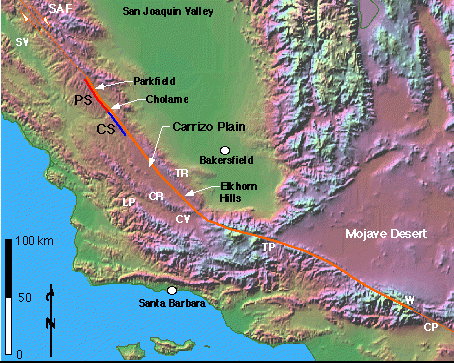
Shaded relief map of central California showing the situation of the Carrizo .n in the Coast Ranges. The orange line shows the surface trace of the SAF, and is thicker along the portion that is inferred to have ruptured in the 1857 earthquake [Sieh, 1978]. The blue line is adjacent to the Parkfield Segment (PS) of the SAF, while the red line is adjacent to the Ch.e Segment (CS). TR is Temblor Range; CR is Caliente Range; CV is Cuyama Valley; LP is La Panza Range; SV is Salinas Valley; CP is Cajon Pass; TP is Tejon Pass; W is Wrightwood. Original relief map is from Relief map of the world: cylindrical projection; elevation data from ETOPO5 dataset; by Ray Sterner, Johns Hopkins University Applied Physics Laboratory.

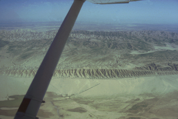
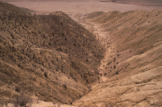
Side looking airborne radar image of the Carrizo .n area. Look Direction is toward northeast. The rugged topography of the Temblor Range along the northeast side of the image is a contrast to the .ter Carrizo .n. The patchwork texture of the Carrizo .n results from variable grazing and farming practives on different properties. Soda Lake is the lowest portion of the Carrizo .n (~1900' elevation). The San Andreas Fault (SAF) follows the southwestern foothills of the Temblor Range. Local relief along the SAF and a more westerly SAF strike increase toward the southeast. In the area of Wa.e Creek in the northwest, little local relief is evident and Recent fault activity has been confined to predominantly strike-slip along a narrow zone. Toward the southeast in the Elkhorn Hills, on the other hand, local relief is evident and secondary fault activity increase, possibly the result of increased contraction across the SAF zone caused by a more westerly strike as it enters the Big Bend.

Aerial photograph of the SAF zone in the central Carrizo .n. The locations of the important.dforms and paleoseismic sites of Wa.e Creek; Ph. Creeks; and Ph. Fan are shown. The trace of the SAF is indicated by the triangles on the lower photo. Note the en echelon, right-stepping pattern of the SAF in this area. Local extension associated with a right step in the southeastern portion of the lower photograph has produced a small graben. The upper two photographs are blow-ups to show the detail of Wa.e Creek and Ph. Creeks. Photograph courtesy of the Fairchild Aerial Photography Collection at Whittier College. Original photograph scale 1:24,000; photograph date 26 February, 1936.

Aerial photograph of the Northern Elkhorn Hills. This image illustrates the important structures and.dforms in this area of distributed deformation adjacent to the San Andreas Fault in the southeastern Carrizo .n. Photograph courtesy of the Fairchild Aerial Photography Collection at Whittier College. Original photograph scale 1:24,000, photograph date 26 February 1936.
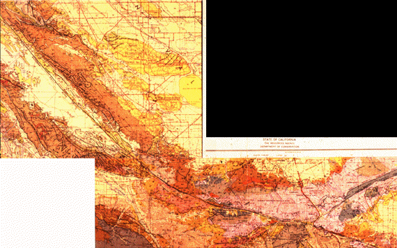
This is a photograph of the 1:250,000 geologic map of the Northern Big Bend of the San Andreas fault. The basin along the fault in the northwestern portion of the map is the Carrizo .n. Notice how the San Andreas fault strike bends more and more to the west as you follow it to the southeast. Thus, the Carrizo .n uniquely captures the structural and geomorphic responses to the changing geometry of the San Andreas Fault. On the northeast, the Temblor Range separates the Carrizo .n from the San Joaquin Valley. Southwest of the Carrizo .n, the Caliente Range separates the Carrizo .n from the Cuyama Valley. Both the southwestern San Joaquin Valley and Cuyama Valleys are important oil producing regions with most of of the petroleum coming from structurally-controlled resevoirs.

View northeast across the San Andreas fault showing several offset stream channels. Main channel is offset about 130 m and was incised approximately 3,700 years ago. Channel farther to left on near side of fault has been dis.ed approximately 350 m, is beheaded, and was incised approximately 10,000 years ago. These offsets and ages provide a long term slip rate of approximately 35 mm/yr along the San Andreas fault here (Sieh and Jahns, 1984). Small gulches at right dis. about 9 m offset from the 1857 earthquake. No fault creep is observed here and this section of the San Andreas fault is considered locked. Sieh and Wa.e (1987) provide a detailed field description of this site. This slide is #13 from Wa.e and Schulz (1983).

This.ge, elongate ridge (3 km along the SAF and a maximum of 500 m wide perpendic. to the SAF) is bounded on the far side by the San Andreas fault. View direction is east-southeast. The pressure ridge is part of a complex of sim. kilometer-scale ridges elongate parallel to the SAF in the southern Carrizo .n. Geomorphic analysis of the gullies on the southwest face of this pressure ridge suggests that the material of the pressure ridge is moved through an upift zone that is stationary r.ive to the northeastern (or North American) block. Drainages initiate on the rising portion of the pressure ridge, develop, and degrade the topography as it moves past the uplift zone. Detailed mapping indicates that the structure is homoclinal, dipping away from the San Andreas fault. The dip direction, as well as the drainage network pattern, indicate that the uplift is accommodated by tilting away from a zone of maxmum uplift as material of the southwest (or Pacific) block moves toward the uplift zone from the southeast. In the zone of maximum uplift, the SAF, and a parallel, southwest-dipping fault in the southwestern third of the pressure ridge, accommodate normal slip, and the central block is uplifted as a horst. After moving through the zone of maximum uplift, material again tilts away from it. The zone of maximum uplift may form as the material of the pressure ridge rides over the footwall of an inferred reverse fault that may offset the SAF at a depth of 0.5 to 1 km.
This is another view of the Dragon's Back Pressure ridge looking northeast. The San Andreas fault follows far side of the Dragon's Back.
This is a view of the Dragon's Back Pressure ridge looking northeast from the ground along Soda Lake Road. The Dragon's Back rises about 100 m above the Carrizo .n. The SAF is immediately behind it, and the escaprment is a part of the Northern Elkhorn Hills.
The following 3 photographs show the view downstream from three gullies across the Dragon's Back. In each, a white truck is parked near the mouth of the drainage. Gully 1 (the least developed) is in the uplift zone. Gully 2 is in the center of the Dragon's Back and Gully 3 is in the northwestern portion of the pressure ridge. The morphology of these drainages change systematically, supporting our hypothesis that the material of the pressure ridge moves through a r.ively stationary uplift zone where drainages initiate. As the material is moved away from the uplift zone, the drainages continue to develop.

This photograph looks north over the northern end of the Big Graben in the NEH. The Temblor Range is in the distance. Both sides of the graben are bounded by active normal faults that began to slip at 62.7 +/- 33.3 ka. That age gives a slip rate of ~1 mm/yr based on morphologic dating of the fault scarp on the extreme right of this picture (see Arrowsmith, 1995 for a discussion of the structural geology and morphologic dating in the NEH). The truck sits on top of a younger fault scarp formed by slip along a newer fault that accomodates slip in the northwestern portion of the Big Graben, shutting down the fault to the northeast (note the more degraded scarp along that graben wall). We dug a trench across the younger fault, but no clear offset stratigraphy was found, probably because the hanging and footwalls are comprised of the same materials. Co.se pits--possibly formed along with the normal faults in response to local tension--are evident to the left of the truck in the base of the Big Graben.

Oblique aerial photograph looking west at the Northern ELkhorn Hills (NEH). Note the association of active secondary folds and normal faults with the San Andreas Fault in this area.
Oblique aerial photograph looking southwest at the Southern ELkhorn Hills (SEH), Caliente Range and Cuyama Valley indicating greater relief along the San Andreas Fault as it enters the northern portion of the Big Bend. Note the association of active secondary folds and normal faults with the San Andreas Fault in this area.
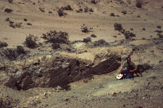
Here, Da. Rhodes and his trusty pal Obi pose in front of a slickensided fault surface exposed along the Emerson Fault in the June 28, 1992 Mw 7.3 Landers, California earthquake. Slickenlines on fault surface plunge northwest 20 degrees. This area is called the Galway Lake Road site. The surface rupture in the Landers earthquake here was not a simple, single surface of slip, but, as documented by Antonellini and others (1992) and Aydin and others (1992), was complex with many en echelon fault surfaces accommodating the offset. The belt of surface fracturing in this area is at least 1 km wide, while the principal dis.ement occurred within a 15-m wide zone (see Johnson and others (1993) for analyses and discussions regarding these broad belts of shear). Within the principal shear zone, the pattern of rupture consists of en echelon right.eral and left.eral, and generally left-stepping, faults with lengths from centimeters to tens of meters, and with offsets varying from millimeters to 3.8 m horizontal and 2 m vertical. Total offsets across the principal shear zone are 4.85 m right.eral, and 2.45 m vertical (down to the southwest). The N30!W rupture zone follows the trace of the Emerson fault. The en Žchelon segments dip steeply (>80!) both to the SW (the one shown here) and the NE Antonellini and others (1992). See Arrowsmith and Rhodes (1994) for a description of ongoing research to document the style of degradation of these faulted.dforms.