Geologic mapping, Geographic Information Systems
management, tectonic geomorphology, and geomorphic and tectonic modeling at
Arizona State University, Contribution to NSF Continental Dynamics program
collaborative research: Transpressional strain partitioning: The Carrizo
Plain segment of the San Andreas Fault.
Compilation of existing geologic data (mapping, wellbore, and industry
seismic), additional geologic mapping of late Tertiary rocks and the detailed
structure within the SAF Zone, paleoseismic trench investigations of active
faults, and geomorphic and tectonic modeling will complement the seismic and MT
data and significantly enhance our ability to interpret them and apply our
results to improve understanding of the partitioning of deformation between
parallel striking strike-slip and thrust faults and folds. This work will be
completed mostly at Arizona State University by Arrowsmith and a graduate
student dedicated to this project for 100% research time. It will comprise a
significant part of the PhD. dissertation of the student at Arizona State
University. A very capable student, George Hilley, will attend ASU starting
fall 1996 and has indicated his interest in this project (see the Carrizo Plain
Active Tectonics web site for a demonstration of work done by he and
Arrowsmith:
http://pangea.Stanford.EDU/~geomech/carrizo/).
Because of the nearby oil rich areas of the Cuyama and southwestern San
Joaquin Valleys, many geologic observations have been made in the Carrizo Plain
area. These include the following studies: Arrowsmith, 1995;
Bartow, 1988; Dibblee, 1962; Dibblee, 1973; Graham et
al., 1989; Vedder, 1970; Vedder and Repenning, 1965;
Vedder and Wallace, 1970; Wallace, 1968; Wallace, 1973;
Wallace, 1975. Along with these data, much data from the petroleum
industry is available, and will be compiled and interpreted by Steve Graham and
his research group. A summary database of geology and data source locations
will be developed at Arizona State University as a Geographic Information
System (see below). This database will permit us to quickly update our maps,
plan field strategies, thoroughly interpret much of the data, disseminate the
observations, and archive the information.
A Geographic Information System is defined as "An organized collection of
computer hardware, software, geographic data, and personnel designed to
efficiently capture, store, update, manipulate, analyze, and display all forms
of geographically referenced information" [ESRI, 1993]. A GIS is a
system of single attribute "layers" of data registered to a common map base. A
model of their interrelationship allows the user to selectively combine,
compare, or modify them. Such actions are the features of a GIS that
distinguish it from a set of maps. The detailed GIS that we will develop will
allow for the integration and comparison of observations and modeled results in
unique way, possibly indicating some non-intuitive or unanticipated results
(Figures 1 and 2). The GIS development will allow us to effectively manage our
large datasets. We will compile geologic and geomorphic observations, remotely
sensed data, and results from the models of deformation and degradation to
assemble a geographically referenced database allowing for the manipulation and
combination of observations, inferences, and model results. Specifically, our
geologic and geomorphic maps will be compiled with 7.5" digital terrain models,
repeat aerial photography, airborne TIMS (Thermal Infrared Multispectral
Scanner), SPOT satellite imagery (these remotely sensed data are already in
hand at Arizona State University; figure 1), field survey data, and calculated
deformation fields and degradation patterns. These observations will be
considered together with the seismic and magnetotelluric databases that will
also be incorporated into our GIS. We will use the GIS facilities at Stanford
University and Arizona State University, and work in collaboration with Carl
Wentworth (US Geological Survey in Menlo Park) who is generating a regional
geologic and geophysical database of the Carrizo Plain area.
Along with the compilation of geologic data, new mapping of Pliocene to Recent
deposits and detailed structures within the SAFZ will constrain the timing and
geometry of regional deformation, thus clarifying the interpretation of the
regional seismic and MT data; as well as the kinematics within the SAFZ, thus
helping with the interpretation of the high resolution seismic data. Again,
these data will be compiled using the GIS. Provenance and paleocurrent data
from Pliocene and younger terrestrial deposits of the Paso Robles formation
north and west of the CP document the uplift of the Temblor Range in the late
Pliocene, causing a reversal of drainage [Dibblee, 1962;
Galehouse, 1967]. In the late Pleistocene, the drainage through the CP
from the Temblor and Caliente Ranges became trapped and a closed basin
developed, shutting off the upper Salinas River basin and forming the Soda Lake
basin in the central Carrizo Plain. We hypothesize that the partitioning of
the regional drainage basins is due to active slip along the crustal scale
thrust faults inferred to underlie the Temblor and Caliente Ranges. In
particular, the proposed documentation of drainage reversal in the Paso Robles
formation and Soda Lake area will provide information on the activity of the
Whiterock-Morales-Big Spring thrust faults underlying the Caliente Range (see
the regional geologic map figure). This portion of the field work will cover
the SAF zone, was well as selected areas in the region such as a ~30
km2 portion of the Paso Robles formation that apparently has been
uplifted about 100 m in the northwestern Caliente Range (see the first figure
of this proposal). We hypothesize that these deposits may provide important
clues to the Plio-Pleistocene history of the region, and thus for the
deformation geometry and rate associated with the apparently active thrust
faults underneath the Caliente Range and that we expect will be imaged in the
geophysical experiments.
Previous mapping of the SAF zone structure and geomorphology in the
southeastern Carrizo Plain has allowed the determination of the geometry and
rate of deformation associated with active structures in the region
[Arrowsmith, 1995; Arrowsmith et al., 1996; Figures 1 and 2]. We
will continue these investigations along the SAF and along the seismic
transect, quantifying geomorphic evidence of active deformation. The
structures illustrated in figures 1 and 2 point out the importance of detailed
mapping of structures and landforms. The combination of both datasets provides
a means of constraining the temporal and spatial distribution of deformation
within the fault zone.
For example, the SAF in the Carrizo Plain changes strike from ~N45W in the
northwest to ~N60W in the southeast over a distance of about 60 km as it enters
the northern portion of the Big Bend. The change in strike results in an
increased component of motion perpendicular to the SAF which may drive the
development of secondary structures and localized uplift. In the northwest,
the strike is deviated < 3deg. from the N45W reference; the secondary
deformation near the fault zone is small, and offset channels (such as Wallace
Creek) are well preserved. In the central Carrizo Plain, the deviation in
strike is 3-9deg. and pressure ridges elongate parallel to and bounded by the
SAF (on the northeast) develop. The largest and southeasternmost one is the
Dragon's Back (DB; see figures 1 and 2). Morphometry such as longitudinal and
cross valley profiles and drainage basin and network development along with
geologic mapping are consistent with the hypothesis that as the DB moves
through a relatively stationary uplift zone, drainages initiate as they enter
the uplift zone and develop as they move through and away from the uplift zone.
In the southeastern Carrizo Plain, the SAF strike is deviated up to 15deg.. A
topographic welt (the Northern Elkhorn Hills--NEH; see figures 1 and 2) has
developed adjacent to and on the northeast side of the SAF beginning just
southeast of the DB. Our geologic mapping and geomorphic investigations
indicate that a southwest dipping reverse fault underlies the NEH and probably
intersects and offsets the SAF. The footwall of the NEH reverse fault may
provide the localized uplift source for the DB. Normal faults have formed
grabens in the hanging wall of the NEH reverse fault. Morphologic dating of
the graben scarps and the beheading of a southwest-draining channel by slip
along the reverse fault are consistent with the inference that the NEH are
moved into the relatively stationary Big Bend and are progressively deformed
and degraded [Arrowsmith, 1995; Arrowsmith, 1992; Arrowsmith
and Rhodes, 1992]. These observations and inferences provide a complex
view of the interacting blocks within the SAFZ over the km-scale. We expect
that the structural and high resolution seismic interpretations proposed would
be complementary.
The mapping effort will be completed by Arrowsmith and a graduate student.
They will extend the geologic mapping presented in Figure 2 along the SAF
northwest past the main seismic line approximately 20 km for a total of 60 km
of fault zone mapping. Despite the apparent breadth of the proposed geologic
and geomorphologic mapping, it is feasible because of our experience in the
area. We have reconnoitered and already mapped portions of the entire section.
We expect to compile unpublished mapping and topographic data from the research
of Alan Bartow, Kerry Sieh, Lisa Grant, John G. Vedder, and John Sims and
colleagues. Not only will we document the active fault segments, but also the
attitude of bedding, the type and quality of tectonic landforms, and potential
sites for detailed paleoseismic investigations. The structural geology will be
analyzed using standard down-plunge views, and fault slip analysis, along with
our numerical techniques. Representative landforms will be selected for
morphologic analysis, and their development simulated with the numerical
methods for geomorphic and tectonic displacements.
Along with the continuation of mapping, our investigations into the
morphologic dating of tectonic landforms (see below) will be tested in a
trenching project across fault scarps adjacent to the SAF. This portion of the
project will provide detailed constraints on the types and rates of processes
controlling geomorphic displacements of tectonic landforms along the SAF zone
in the Carrizo Plain. This continuation of the calibration process will help
us apply the morphologic analyses of selected tectonic landforms identified in
our mapping in order to characterize the temporal development of the SAF zone
in the Carrizo Plain. For example, normal faults cut the hanging wall of the
NEH thrust faults (Figures 1 and 2). We hypothesize that the normal faults
and the thrust faults are related mechanically. The normal faults probably
slip a few tens of cm in each earthquake rupture along the nearby San Andreas.
Even if we do not find dateable material, we can determine the amount of slip
per event by looking at the colluvial material adjacent to the fault scarps.
If dateable material is found, we may determine the slip rate along that normal
fault, and thus compare it with the best-fitting slip rate determined using the
morphologic techniques.
Morphologic dating of fault scarps characterizes the timing of late Cenozoic
fault activity by quantitatively comparing observed topographic profiles with
those determined using a calibrated landscape development model. This method
complements detailed paleoseismic trenching investigations by providing lower
precision ages over broader areas at lesser expense. Our model assumes
transport-limited conditions and applies to slopes over which the material
transport rate is proportional only to local slope (diffusion erosion).
[Arrowsmith et al., 1995a; Arrowsmith et al., 1995b] calibrated
the material transport rate constant at a site where the timing is well
established (Wallace Creek), and then dated other fault scarps in the region.
The model was calibrated using 9 profiles along the southwest-facing scarp
southeast of Wallace Creek in the Carrizo Plain. This scarp has been exposed
by lateral offset of a southeast-sloping shutter ridge along the
northwest-striking San Andreas Fault (SAF), and by vertical offset related to
local deformation. This reconstruction is supported by the established
geologic history which provides an average Holocene slip rate of 3.5 cm/yr.
The initial profiles are identified by projection of remnants of an incised fan
surface to the SAF. The lower end of each profile (at the SAF) drops at a rate
determined by the difference in elevations between the inferred initial profile
and the observed final profile taking into account the time since exposure of
that portion of the scarp by passage of the shutter ridge. Given those
assumptions, the average rate constant (diffusivity) is 8.5+/-1.8
m2/ka at Wallace Creek. This result is qualitatively reasonable in
that it is between the 1 m2/ka determined for the Basin and Range
and the 11 m2/ka determined for the Santa Cruz seacliffs [e.g.,
Hanks et al., 1984; Rosenbloom and Anderson, 1994]. We expect to
improve the calibration in our proposed investigation by trenching selected
sites and performing further morphologic tests.
The important application of this technique is that we can determine slip
rates along the many faults within the SAFZ in the Carrizo Plain area because
we can assume that they will have experienced similar climate, we can choose
profiles with a similar aspect (a similar facing direction will minimize
microclimatic effects), and we can establish that they scarps are developed in
similarly resistant to erosion materials (i.e,. the Paso Robles Formation and
other Quaternary deposits). Determining slip rates along the various faults of
the region will permit us to quantitatively document the degree of strain
partitioning and to develop mechanical models for the interaction between these
structures (see below). As an example of morphologic dating in the area,
Figure 3 illustrates how normal fault slip rates were determined for two
graben-bounding faults in the Northern Elkhorn Hills in the southeastern
Carrizo Plain by applying the calibrated model to determine the scarp ages.
These scarps are cut into the same material, face the same direction, and
presumably have the same climatic history as those at Wallace Creek (only 30 km
northwest). Slip rates for these faults are a few millimeters per year, and
the northwestern one is about 12 k. y. old while the other is about 63 k. y
old. We infer that the normal faults form above reverse faults that
accommodate increasing contraction adjacent to the SAF as them material enters
the Big Bend. Because one graben is 50 ka older than and 1 km southeast of the
other, they progressively develop at a rate of about 2 cm/yr. These slip rate
determinations have been incorporated into a Geographic Information System
database that permits us to investigate the relationships between the
progressive development of the normal faults and detailed geologic and
geomorphic mapping, and mechanical models of the geologic structures
[Arrowsmith et al., 1995b; Hilley and Arrowsmith, 1995a;
Hilley and Arrowsmith, 1995b].
In order to mechanically test the hypothesized geometries of structures that
are observed in the geophysical data, as well as inferred in the balanced
cross-section work of Steve Graham and his students, we will use a numerical 3D
mechanical model of interacting faults. We model surface displacements and
mechanical interaction between various faults using polygonal displacement
discontinuities and with uniform displacement discontinuity and or uniform
tractions along each element and a remote stress field [Erikson, 1987;
Okada, 1985; Thomas, 1993]. These techniques calculate the
elastic fields (displacements, stresses, strains, and tilts) caused by any
amount of strike-slip, dip-slip, and opening displacement discontinuity or
traction on any number of arbitrarily striking and dipping fault elements. 2
dimensional models of interacting faults with variable friction will also be
developed and compared with our observations [e.g., FRIC2D, Cooke and
Pollard, 1994] and those of the regional contemporary stress state [e. g.,
Castillo and Zoback, 1994]. Such methods are commonly used for modeling
displacements associated with slip events on faults and the stress changes
associated with earthquakes [e. g., Reasenberg and Simpson, 1992].
Because the some of the sources of the measured deformation appear to be
dominantly located in the upper crust, elastic models are a useful tool for
this portion of the study. Aseismic shear or flow below the seismic upper 15 km
of the crust are also represented by buried dislocations [e.g.,
Bürgmann et al., 1994; Lisowski et al., 1991; Thatcher
and Lisowski, 1987]. Traction boundary conditions permit us to specify
remote stresses determined from other geologic or geophysical data, or a fault
may perturb the stress field, and the tractions along fault elements of
interest may be resolved, the corresponding displacement discontinuity
determined, and the surface displacement fields calculated [Thomas,
1993]. We proceed with the elastic analysis in order to characterize the
short-term tectonic displacement distributions due to single or multiple events
that are additive in a time independent fashion. To a first-order, this
approach is an improvement over kinematic models such as block motion, in which
one portion of the body is moved rigidly relative to the other. In such a
model, there is no strain within the blocks being moved; here we explicitly
include deformation and interaction. Furthermore, the relationship between
surface folds and blind thrusts may be studied by means of cross-section
balancing techniques [e. g., Suppe and Medwedeff, 1990], and those
methods will be complemented using these three-dimensional mechanical tools
[e.g., Taboada et al., 1993].
Figure Captions.

Figure 1. Panchromatic SPOT image (courtesy of SPOT Image Corp.) of the
southeastern Carrizo Plainillustrating the geography, physiography, and
geomorphology of the Caliente Range foothills (at the bottom); the southeastern
Carrizo Plain (center); and the Elkhorn Scarp--defined in the northwest by the
pressure ridges, including the Dragon's Back, and in the southeast by the
southwest side of the Elkhorn Hills (northeast of the SAF, NEH is Northern
Elkhorn Hills, and SEH is Southern Elkhorn Hills). The Elkhorn Plain separates
the Elkhorn Hills from the Temblor Range (at the top right).
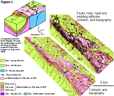
Figure 2. Sample geologic map generated from the Arc-Info database
illustrating the detail of geologic mapping and the association of normal and
reverse faults with the SAF in this area. These plots are still under
development but illustrate our GIS capability [Hilley and Arrowsmith,
1995b]. Conceptual isometric block diagram of a portion of the Northern
Elkhorn Hills through the southeastern end of the Dragon's Back pressure ridge
is shown in the upper left. Note that if the SAF is offset by slip along the
thrust fault, it is too deep to develop the localized deformation necessary for
pressure ridge uplift. However this material is tilting to the south, away
from the uplift zone. The intersection between the SAF and the thrust fault
must become shallow rapidly because it may be at ~500 m depth 1 km to the
northwest. The location of this block diagram shown on the geologic map in the
upper right of figure 2.. The block is 1 km long parallel to the SAF, and 2 km
long perpendicular. Topography and structures are vertically exaggerated 2x.
The subsurface structure is constrained by interpretation of well logs, down
plunge projection of structures and inferences of similar horizontal and
vertical scales of structures, but clearly could complement and be complemented
by the high resolution seismic data that we propose to acquire.
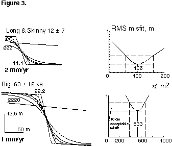
Figure 3. Morphologic dating results of NEH graben scarps for diffusion
erosion case (m = 0, n = 1). The locations of the scarp profiles
shown in Figure 1 (L&S = Long and Skinny). The initial shape is a 1.2deg.
sloping surface (solid line), the final shape with no geomorphic displacements
is dashed, the observations dotted, and the model profiles solid (shown with
corresponding morphologic age). All boundary conditions are constant flux of
zero (used to simulate the rounding of the upper crest and the filing of the
graben). The angle of repose is assumed to be 35deg.. Also shown are the
distributions of model misfit [e.g., Avouac and Peltzer, 1993;
Avouac, 1993].
E.S.R.I., Understanding GIS: the ARC/INFO Method, Longman
Scientific & Technical, 1993.
Arrowsmith, J.R., Coupled tectonic deformation and geomorphic degradation along
the San Andreas Fault system, PhD. Dissertation, 347 p. thesis, Stanford
University, 1995.
Arrowsmith, J.R., R. Bürgmann, and T.A. Dumitru, Uplift And Fault Slip
Rates in the Southern San Francisco Bay Area From Fission Tracks,
Geomorphology, and Geodesy, in submitted to The Geological Society of
America Special Paper 3XX, Quaternary Geochronology, edited by J. Noller,
and W.A. Lettis, 1995a.
Arrowsmith, J.R., D.D. Pollard, G. Hilley, and D.D. Rhodes, Morphologic dating
of scarps along the San Andreas fault, Carrizo Plain, California and
progressive deformation along the Big Bend, EOS Transactions AGU, 1995 Fall
AGU Meeting, 1995b.
Arrowsmith, R., Progressive deformation and degradation along the northern
portion of the Big Bend of the San Andreas fault, Geological Society of
America Abstracts with Programs, 24 (7), A147, 1992.
Arrowsmith, R., D.D. Pollard, and D.D. Rhodes, Hillslope development in areas
of active tectonics, Journal of Geophysical Research, Special Section on
Paleoseismology, in press (March 1996)., 101 (B3), 6255-6275,
1996.
Arrowsmith, R., and D.D. Rhodes, Kinematics, structure, and degradation of
pressure ridges along the San Andreas fault in the Carrizo Plain, San Luis
Obispo County, California, Geological Society of America Abstracts with
Programs, 24 (5), 3, 1992.
Avouac, J.-P., and G. Peltzer, Active tectonics in southern Xinjiang, China;
analysis of terrace riser and normal fault scarp degradation along the
Hotan-Qira fault system, Journal of Geophysical Research, B, Solid Earth and
Planets, 98 (12), 21,773-21,807, 1993.
Avouac, J.P., Analysis of scarp profiles: evaluation of errors in morphologic
dating, Journal of Geophysical Research, 98, 6745-6754, 1993.
Bartow, J.A., Geologic map of the northwestern Caliente Range, San Luis
Obispo County, California, United States Geological Survey, Open-File
Report 88-0691, 1988.
Bürgmann, R., P. Segall, M. Lisowski, and J.P. Svarc, Post-seismic strain
following the 1989 Loma Prieta earthquake from repeated GPS measurements,
U.S. Geol. Surv. Prof. Pap., 1550, in press, 1994.
Castillo, D.A., and M.D. Zoback, Systematic variations in stress state in the
southern San Joaquin Valley; inferences based on well-bore data and
contemporary seismicity, AAPG Bulletin, 78 (8), 1257-1275,
1994.
Cooke, M., and D.D. Pollard, Development of bedding plane faults and fracture
localization in a flexed multilayer: A numerical model, in Proceedings of
the 1st North American Rock Mechanics Symposium, edited by Nelson, and
Laubach, pp. 131-138, Balkema, Rotterdam, 1994.
Dibblee, T.W., Displacements on the San Andreas rift zone and related
structures in Carrizo Plain and vicinity., in Guidebook: geology of Carrizo
Plains and San Andreas fault, edited by O. Hackell, pp. 5-12, San Joaquin
Geological Society and Pacific Section, AAPG and SEPM, Bakersfield, California,
1962.
Dibblee, T.W., Regional geologic map of the San Andreas and related faults in
Carrizo Plain, Temblor, Caliente, and La Panza ranges and vicinity, California,
United States Geological Survey Miscellaneous Geologic Investigations Map
I-757, 1973.
Erikson, L.L., DIS3D: A three dimensional dislocation program with
applications to faulting in the earth, MS. thesis, Stanford University,
Stanford, CA, 1987.
Galehouse, J.S., Provenance and paleocurrents of the Paso Robles formation,
California, Geological Society of America Bulletin, 78, 951-978,
1967.
Graham, S.A., R.G. Stanley, J.V. Bent, and J.B. Carter, Oligocene and Miocene
paleogeography of central California and displacement along the San Andreas
fault, Geological Society of America Bulletin, 100, 711-730,
1989.
Hanks, T.C., R.C. Bucknam, K.R. Lajoie, and R.E. Wallace, Modification of
wave-cut and fault-controlled landforms, Journal of Geophysical
Research, 89, 5771-5790, 1984.
Hilley, G., and J.R. Arrowsmith, Carrizo Plain Active Tectonics Web Site,
http://pangea.Stanford.EDU/~geomech/carrizo/, 1995a.
Hilley, G., and R. Arrowsmith, A GIS applied to active tectonics, in ACTIVE
FAULTING STUDIES FOR SEISMIC HAZARD ASSESSMENT Erice, Sicily, 27 September-5
October 1995; sponsored by Instituto Nazionale di Geofisica, International
Lithosphere Program, Global Seismic Hazard Assessment Program of the United
Nations (U. N. E. S. C. O.)., 1995b.
Lisowski, M., J.C. Savage, and W.H. Prescott, The velocity field along the San
Andreas Fault in Central and Southern California, Journal of Geophysical
Research, B, Solid Earth and Planets, 96 (5), 8369-8389, 1991.
Okada, Y., Surface deformation due to shear and tensile faults in a half-space,
Bulletin of the Seismological Society of America, 75, 1135-1154,
1985.
Reasenberg, P.A., and R.W. Simpson, Response of regional seismicity to the
static stress change produced by the Loma Prieta earthquake, Science,
255 (5052), 1687-1690, 1992.
Rosenbloom, N.A., and R.S. Anderson, Hillslope and channel evolution in a
marine terraced landscape, Santa Cruz, California, Journal of Geophysical
Research, Tectonics and Topography Special Volume, 99, 14013-14029,
1994.
Suppe, J., and D.A. Medwedeff, Geometry and kinematics of fault-propagation
folding, The Hans Laubscher volume Eclogae Geologicae Helvetiae, 83,
No. 3, 409-454, 1990.
Taboada, A., J.C. Bousquet, and H. Philip, Coseismic elastic models of folds
above blind thrusts in the Betic Cordilleras (Spain) and evaluation of seismic
hazard, Tectonophysics, 220 (1-4), 223-241, 1993.
Thatcher, W., and M. Lisowski, Long-term seismic potential of the San Andreas
Fault southeast of San Francisco, California, Journal of Geophysical
Research, B, Solid Earth and Planets, 92 (6), 4771-4784, 1987.
Thomas, A.L., Poly3D : a three-dimensional, polygonal element, displacement
discontinuity boundary element computer program with applications to fractures,
faults, and cavities in the Earth's crust, M.S.; 221 p. thesis, Stanford
University, 1993.
Vedder, J.G., Geologic map of the Wells Ranch and Elkhorn Hills quadrangles,
San Luis Obispo and Kern counties, California, showing juxtaposed rocks along
the San Andreas Fault. United States Geological Survey Miscellaneous Geologic
Investigations map I-585, U.S. Geological Survey, Washington, D. C., 1970.
Vedder, J.G., and C.A. Repenning, Geologic map of the southeastern Caliente
Range, San Luis Obispo County, California, U. S. Geological Survey, Oil and
Gas Investigations Maps ; OM-0217, 1965.
Vedder, J.G., and R.E. Wallace, Map showing recently active breaks along the
san andreas and related faults between cholame valley and tejon pass,
california, U.S. Geol. Survey Misc. Geol. Inv. Map I-574, Washington, D. C.,
1970.
Wallace, R.E., Notes on stream channels offset by the San Andreas fault, in
Proceedings of conference on geologic problems of the San Andreas fault,
edited by W.R. Dickinson, and A. Grantz, Stanford University Publications in
the Geological Sciences, Stanford, California, 1968.
Wallace, R.E., Surface fracture patterns along the San Andreas fault, in
Proceedings of the Conference on Tectonic Problems of the San Andreas fault
system, edited by R.L. Kovach, and A. Nur, pp. 248-250, Stanford
University Publications in the Geological Sciences, Stanford, California,
1973.
Wallace, R.E., The San Andreas fault in the Carrizo Plain--Temblor Range
region, California, in The San Andreas fault in southern California,
edited by J.C. Crowell, pp. 241-250, California Division of Mines and Geology,
1975.