ACTIVE TECTONICS IN THE PAMIRS
This page is under construction. It is dedicated to the investigation of
active tectonics in the Pamirs.
Summary
This project will develop a research program on active earthquake deformation
of the northern foothills of the Pamir Mountains, Kyrgyzstan with European
colleagues to address basic problems in the formation of large mountain belts
and applied problems in the mitigation of earthquake hazards.
Problems
Along leading edge of the Pamir Mountains is a fault system that accommodates
some of the deformation associated with the collision of India with Eurasia.
Because of the arid environment, lack of human degradation of the landscape,
spectacular exposures of the effects of recent earthquakes and of the uplift of
the mountain, this area is a premier natural laboratory for the investigation
of the following significant problems:
1) As India has collided with Eurasia over the last 40 million years, the
deformation has spread to the interior of Eurasia, uplifting Tibet, and driving
faulting as far north as Lake Baikal. The collision and this deformation
continue today. The partitioning of that
deformation among the different blocks and their bounding faults in both space
and time is an outstanding question in our understanding of large-scale
continental deformation.
2) We assume that earthquakes and their associated secondary deformation are
the quantum deformation events by which most mountain building occurs: if
enough earthquakes are repeated, they will accommodate the large scale
continental deformation, mountains will be built, and rocks will be permanently
deformed. By investigating an area where active deformation in the form of
earthquakes occurs as well as where the longer term deformation is evident in
the nearby mountain range, we may substitute space for time, and investigate
how the short term deformation is accumulated into longer-term mountain growth.
3) The earthquakes and associated geologic structures are analogous to those
in the Los Angeles Basin such as that along which the devastating Northridge
earthquake. Similar structures exist in Caucasus,
Indian and Nepal Himalayas. The proposed research will provide data on the
geometry and rates of deformation of these types of structures as well as
promote the development of computer mapping and modeling tools for their
characterization. Therefore the results from this work may be applied to the
characterization of the significant geologic hazard that these structures pose
to the Los Angeles Basin.
Hindu
Kush-Pamir seismicity from John Hernlund
NSF Proposal Project summary
Nice images of the area
Arrowsmith and Strecker GSA Bulletin manuscript has been acdepted (March
18, 1999)!
Abstract for GSA '97
The Alai Valley in 3D:
perspective view of Landsat TM draped on DEM,
looking toward the southwest over the Trans Alai Mountains
(image by S.
McManus)
Here are some more:
Zoom to
the southwest
View to the
east
View to the
southeast
View to the
west
Nice view up the Altyn Dara Valley
Pamir Hypsometry from Sean McManus
Map of topography and hypsometry of the Pamir region and central Asia
Map of topography and hypsometry of ~300 km2 drainage basins
of the Pamir region and central Asia
Average hypsometry along profiles perpendicular to the tectonic fabric
Average hypsometry along profiles parallel to the tectonic fabric along
the Kyzyl Su River
Recently produced topographic maps document active faulting in the Northern
Pamirs
Central Asia field location
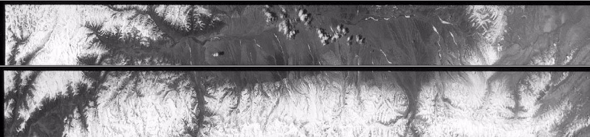
Stereo satellite photos
View of the Alai Valley (the north edge of the Pamir Mountains).
Thrust faults
along the south portion of the valley are one of the focuses of this project.
These are two US Declassified Intelligence Satellite Photos.
Proposal for Summer '96 project
Hits since April 18, 1998:

Pages maintained by
Prof. Ramón Arrowsmith
Last modified March 25, 1999