GLG310 Structural Geology 2004 Simple Structure Contours and Orthographic Projection Lab
Simple Structure Contours, Orothographic Projection, and Planes and Topography
Most of this is explained in Chapter 4 (Planes and Topography) of Ragan and Arrowsmith and also in Appendix III-G in Davis and Reynolds. You have see this already in last week's lab, but this week we will work to quantify it and to have you become empowered to use your pencil, eraser, protractor, and ruler to figure things out.
- Rule of Vs. Recall last week's lab. Look at figures 4.4 and 4.5 in R+A Ch. 4.
- Let's look at this modified version of figure 4.6 from R+A Ch. 4. Note the concept of Folding Line.
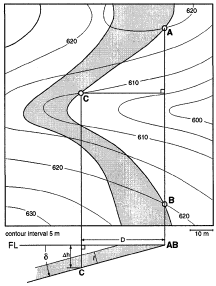
Structure contours:lines of equal elevation on a buried or eroded surface.
We want to figure out the strike and dip and thickness of this layer whose outcrop pattern is on the map:
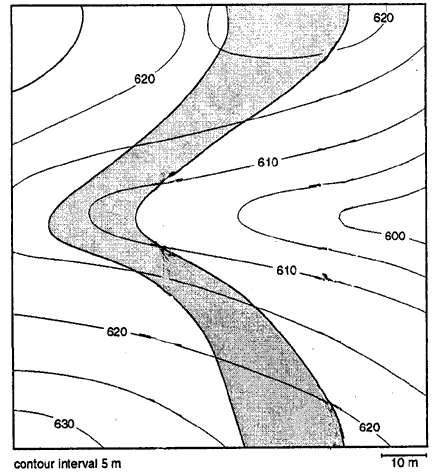
Here is the graphical solution:
- Here is some practice:

HORIZONTAL!

N48W 11NE!
- Here is practice on this thrust fault:

Here is the complete solution:

- Predicting outcrop patterns: Look at how it is done in figures 4.12 and 4.13 in R+A Ch. 4. Also have a look at this handout to see another explanation:
Marshak and Mitra handout
- Here is a demonstration from the area around Camp Tontozona (where we teach Field II--the attitudes are not quite the same, but the topography is).
Older bed has an attitude of N70W25NE at A (that is its top). It is 100' thick. Plot its outcrop pattern and structure contours. A younger dike is vertical with west side at 'o' in 'Canyon.' Strike is N10W; it is 50' wide. Plot the outcrop pattern. 1 mm = 10' Contour interval is 40':

And here is the graphical solution:

Homework
1) Finish the last demo (Camp Tontozona topography). Note that I have only drawn one of the structure contours.
2) Do problem 2 in the R+A Chapter 4. Handout. The very last page has a full size map. Hints:
- Draw the various layers in order from youngest to oldest (saves a lot of erasing because the younger ones have to cut the older ones).
- Watch out for small protrusions of topography (especially for the horizontal layers).
- Conformable means that the overlying layer has the same attitude as the underlying one.
- Color the units uniquely.
- Use an extra sheet of paper (tape it to the map) for the construction (folding line and structure contours).
- Just use the elevations/contours that are multiples of 10 (360, 370, 380, 390, etc.) and interpolate by eye between them for the 5 m contours (note that the contour interval is 5 m).
- Use the expected position of the dipping layer where it would have been if it had not been eroded and the Cretaceous laid down to estimate a little better where the upper contact trace should go.
To be turned in next Thursday at the beginning of lab.
Last modified: September 18, 2004