"Virtual" Planes and topography exercise
The purpose of this exercise is to help build your abilities to work with topographic maps and to gain intuition about how dipping layers may appear in outcrop patterns in realistic topography. In our next lab, you will learn methods to quantify the determination of strike and dip from mapped outcrop patterns.
These images and ideas come from Professor Steve Reynolds.
I expect that you will work your way through the web pages I suggest below and then to perform the two sets of exercises and turn the maps in at the beginning of lab next week..
Note that these web pages generally need QuickTime (QTVR) to be installed as a
plugin for your browser. This is the case for the computers in the
Geological Sciences Department Geological Instructional
Computing Facility. To rotate the movie, click and drag your mouse to either
the left or the right. Some movies also permit you to tilt the terrain up
or down by clicking and dragging your mouse up and down. Some movies begin
with a perspective viewed toward the north (the little red triangle). Note
that if you push shift, you can zoom in on most movies, and ctrl zooms out.
Tasks:
1) Have a look around these web pages and play with the images there:
The
Gallery of Apparent dips
http://geology.asu.edu/%7Ereynolds/apparent_dip/apparent_dip_gallery.htm NOTHING TO TURN IN.
2) Look at the Structure
Map 3D Gallery (http://geology.asu.edu/~reynolds/structure_map3d/structure_map3d_gallery.htm).
Again, look through all of the links. The key consideration is "How does
the outcrop pattern of the layer vary with its dip?"
Look at the simple hill. Here you start to get a feel for what the changing dip of a simple plane does as it intersects the topography. Play with it and also the Simple Valley.
Using the handouts of the topographic maps for those two movies, trace the contact at dips of 0, about 30 (TO THE LEFT AND RIGHT), about 60 (TO THE LEFT AND RIGHT), and 90 degrees. TURN THESE MAPS IN.
Using the New River Mesa, Arizona: Layer dipping 20 degrees -- (use the Large Version if you are on a fast connection; http://geology.asu.edu/~reynolds/structure_map3d/strmap_nrm_layer2_hr.mov) and the handout of the New River Mesa topography, please do your best to trace the outcrop pattern onto the contour map. TURN THIS MAP IN.
Using the Poland Junction, Arizona: Gently dipping layer -- ( use the Large Version if you are on a fast connection; http://geology.asu.edu/~reynolds/structure_map3d/strmap_poland_layer06_hr.mov) and the handout of the Poland Junction, AZ topography, please do your best to trace the outcrop pattern onto the contour map. TURN THIS MAP IN.
Questions to answer on a separate sheet of paper (TURN
IN):
a) What is the outcrop
pattern if the layer has a 0 degree dip?
b) What is the outcrop
pattern if the layer has a 90 degree dip?
c) How does the outcrop
pattern compare to the contours if the dip is small? How about if it is
nearly vertical?
3) Finally, let's apply what you know:
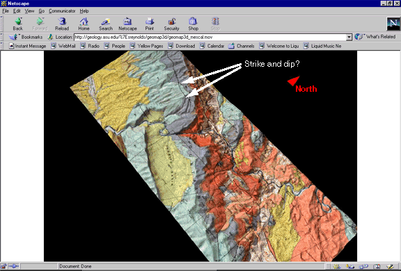
Looking at the geologic map
of the "Mescal
Mountains, Arizona: Strike ridges and dip slopes of Paleozoic and
Precambrian strata; Tertiary normal faults; Late Cretaceous pluton" as shown in
Steve's 3D Geologic
Map Gallery
The North direction is indicated by the red triangle.
d) What is the approximate strike
and dip of the interface between the light blue and purple layers (TURN IN WITH
ABOVE ANSWERS; see figure below)?: