| Relief Evolution at the Fluvial/Glacial Transition |
 |
Project Summary
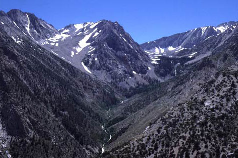
Personnel: Simon Brocklehurst (Ph.D.) Most mid- and high-latitude mountain ranges have been sculpted dramatically by glacial erosion. The isolated spires, narrow ridges, long bare-rock hillslopes, and broad valleys of alpine terrain immediately give a qualitative impression that glaciers are highly efficient erosive agents and that glacial erosion produces considerable relief. However, little is known quantitatively about the rates and patterns of glacial erosion, the factors that control them, nor even the morphological consequences of a shift from fluvial (non-glacial) to glacial erosion. This lack of knowledge is unfortunate given the broad interest in developing a quantitative understanding of the long-term evolution of topography in orogenic belts, and the associated geodynamic and thermo-mechanical consequences of the rates and patterns of erosional unloading (e.g. Koons, 1989; Molnar and England, 1990; Beaumont et al., 1992; Isacks, 1992; Hoffman and Grotzinger, 1993; Merritts and Ellis, 1994; Koons, 1995; Beaumont et al., 1996; Batt and Braun, 1997). In this context, the potential for strong dynamic coupling between climatic and tectonic processes has sparked intense cross-disciplinary interest and debate (e.g., Raymo et al., 1988; Hicks et al., 1990; Molnar and England, 1990; Hallet et al., 1996; Brozovic et al., 1997). The issue of whether or not glaciers primarily deepen valleys and increase topographic relief is central to this debate and yet has never been studied in a systematic way. Given the many unknowns in the glacial erosion problem (e.g., Hallet, 1979; Oerlemans, 1984; Hooke, 1991; Harbor, 1992; Hallet, 1996; MacGregor et al., 1998) perhaps the greatest challenge lies in the discovery of well-posed, tractable problems directly relevant to the issue of the landscape-scale effects of glacial erosion. One promising approach that we propose here is to exploit natural laboratories at the southern limit of glaciation where adjacent fully-, partially-, and un-glaciated, but otherwise similar, basins can be studied. In the right field settings one may estimate quantitatively the amount and pattern of topographic change attributable to glacial erosion alone as a function of the intensity of glaciation. We identify two such field settings in the eastern Sierra Nevada, California, and the northern Sangre de Cristo range, Colorado. We propose a research program in these two field settings combining field mapping, DEM analysis, and cosmogenic isotope dating to test quantitatively 5 hypotheses developed during a preliminary investigation of glacial landforms and erosion:
|
| Mars: Athabasca Valles |
|||||
| Nepal:
Active Thrust Systems |
New
Zealand: Knickpoint Migration |
Relief
Evolution: Active Tectonics |
Relief
Evolution: Fluvial to Glacial |
King Range, CA: Channel Response |
Current
Projects |