
GLG 455/598 Advanced Field Geology
February 7-February 8, 1998
Evaluation of the geometry and activity of this landslide is an area of interest for both the Arizona Department of Transportation and the Arizona Geological Survey.
Location: Just northeast of the second Black Canyon City exit from I-17.
Mapping goals: Determine the extent of the slide, infer its structure, and estimate the variation in the displacement field over the area.
Mapping strategy; Document the following:
1) Distribution of rock types. Where are the main units, what are they (describe them carefully and completely), and what did they look like before the slide began to move. Do they have an effect on the slide's geometry?
2) Location and displacement discontinuity across fractures. Mark as carefully as possible where all of the fractures (faults, opening fractures, etc.) are located. What kinds of relative motion occur across them? Use this kind of notation to document the components of the displacement discontinuity vector (where you can estimate them):
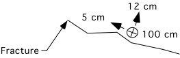
Where the heavy line is the fracture trace on the map. The circle with the x in it is the vertical component (this side down) of the displacement discontinuity vector (and is in this example 100 cm), and the two arrows document the fracture normal and fracture parallel horizontal components of the displacement discontinuity vector.
3) Be sure to quality control your observations. Map broken or disrupted ground and see if its distribution corresponds to broader patterns in the map.
4) Map other landforms and features in the area that may be useful to define the context within which the slide has developed.
Questions to address in the write-up (Due February 23 by 5 PM to Arrowsmith)
(should be five pages plus any figures [which will include your field maps, any other sketches of key relationships that illustrate your points, and a cross-section along the slide, using either the topography from the quad map or other data we may acquire while surveying]):
1) What is the extent of the slide? What defines it? How is it separated from the unslid material around it?
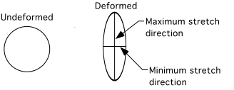
2) What is the overall sense of motion of the slide? What are the directions of the maximum horizontal shortening or extension across the map area (try to identify zones of consistent deformation style; see below and try to identify relative magnitudes and directions of the principal stretches across the slide--see below)? How much deformation occurs along the margins of the slide versus its interior? At what rate do you estimate that the slide is moving? What is the relationship between the slide deformation pattern and topography? Based on our distribution of monuments that we install, what do you think we will observe in terms of their motions relative to a stable point off the slide (one of our instrument stations)?
3) What is the relationship between the slide and the rocks in which it is developed? Why is the slide here? What controls the distribution of deformation?
4) What hazard (if any) does this landslide pose to the residents of Black Canyon City? What is your worst case scenario? What is likely? What could be done to mitigate the hazards you have identified?
5) What role do you think that landslides like this play in the long-term development of slopes in the region? Is it unique? Be sure to look around you and think about the long-term picture.