Cholame and Carrizo SAF field trip stops
Suggestions from Ramon Arrowsmith, Lisa Grant, and Dallas Rhodes.
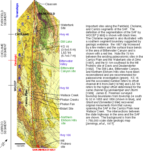
Introduction to the Cholame and Carrizo segments of the SAF
In order to determine the size and extent of past ruptures along the
south-central San Andreas Fault (SAF) and formulate and test hypotheses of
fault segmentation, we need more information about the behavior of the
Cholame segment of the SAF. Paleoseismic data will permit us to infer the
timing of previous earthquakes, and by correlation with events inferred
for the Carrizo and Mojave segments we may determine rupture extent in
events along the SAF and whether or not the ruptures have characteristic
extent and slip distributions. As the 1994 Working Group pointed out, the
gaps in data along the Cholame and northwestern Carrizo segments make
interpretation of slip per event and recurrence intervals difficult. There
are large gaps in paleoseismic sites along the south-central SAF. The
Watertank site is about 3 km NW of Highway 46 [Sims, 1987]. The next
paleoseismic sites are on the Carrizo Plain at Phelan Creeks [Sims, 1994;
Sims et al., 1989], Phelan Fan [Grant and Sieh, 1993], and the Bidart site
[Grant and Sieh, 1994], about 70 km SE of Highway 46. Within those ~73 km,
there are several sites for paleoseismic investigations.
Suggested field trip stops
The two sites at which we have spent the most time in reconnaisance are
the Bitterwater Canyon and Still Lake sites. We have not excavated at
either. Note that you can see the
location of these sites and other features along the SAF in this area in
the figure at: http://www.public.asu.edu/~arrows/cpgeo.gif.
Bitterwater Canyon--Top choice
The Bitterwater Canyon site is located on a fluvial terrace in a wide
portion of the typical gorge-like Bitterwater Canyon (see
http://www.public.asu.edu/~arrows/stereos.gif for stereo airphotos of
this site and Still Lake). The deposits there are interfingering fluvial
deposits from Bitterwater Creek and alluvial deposits from the drainage to
the NE. The aerial photographs and our field mapping indicate that the SAF
formed a 0.5 to 1 m high moletrack along here in 1857 (see
http://www.public.asu.edu/~arrows/BitterDetail.html for a detailed
look at the site).
Portions of the mole track have been buried by the alluvial material. If
previous ruptures were similar, the distortion and vertical displacement of
the ground surface may be preserved by the burial from the fluvial and
alluvial fan materials. We expect that the relatively low relief surface
may permit the growth of grasses and peats that should have been buried by
the relatively rapid sedimentation. The deposition of alluvial material
should be rapid enough to minimize the bioturbation that would probably be
seen on other portions of the terrace surface.
Still Lake--second Cholame choice
The Still Lake site is a depression within a right step along the SAF (see
http://www.public.asu.edu/~arrows/stereos.gif for stereo airphotos).
Its lowest portion contains evaporites and salt tolerant plants indicating
that it is a sag pond. John Sims and colleagues surveyed the site as a
potential paleoseismic candidate. Arrowsmith and Rhodes reconnoitered it
in November 1995, and produced a map of the principal landforms and fault
traces using Sims' topographic data (see
http://www.public.asu.edu/~arrows/StillDetail.html for a detailed
look at the site). We also mapped a 2 km reach of the
SAF centered on Still Lake in summer 1997.
Carrizo Plain site
We don't know what Charlie Rubin has in mind for the Carrizo Plain, but
one site that we have considered in the past is in the Northern Elkhorn
Hills (note its location on the overview figure and the stereo views and
detail in
http://www.public.asu.edu/~arrows/NEH.html). An event chronology
from this site could permit us to determine the extent of events that
rupture the Cholame segment and possibly the central Carrizo sites. Do
ruptures only occur on the Cholame segment? Do they get much further
southeast than the Central Carrizo sites [Grant and Sieh, 1993; Grant and
Sieh, 1994]? Or do they rupture through the southeastern Carrizo Plain
and into the Big Bend? This site probably has tens of cm of vertical
offset (southwest side up) in each SAF rupture. The vertical offset is
accommodating uplift of the Dragon's Back pressure ridge (this is the
southeasternmost portion of the Dragon's Back; [Arrowsmith, 1995;
Arrowsmith and Rhodes, 1992]). Therefore, we expect to observe the
formation of a colluvial wedge with each offset event and the low relief
of the site should permit the healthy growth of grasses that would be
buried and preserved after each event.
Investigation of historic land surveys
In 1855 and 1856, James E.
Freeman surveyed Township and Range lines in the region of the Carrizo
Plain and northward.
Grant and Donnellan, 1994 recovered original monuments from that survey
spanning the SAF in the Carrizo Plain near Wallace Creek and determined
that the 1857 slip along the SAF between those monuments was 11 ± 2.5 m.
While most of the monuments have been moved, destroyed, or otherwise lost,
the possibility of recovering a few more along the Cholame segment is
conceivable. We have found several in the field and Lisa Grant has
collected an extensive history of numerous monuments. A stop in the
northern Carrizo Plain or Cholame segment could include a visit to one of
these corners and a discussion of this promising dataset. Have a look at
one of the corners at
http://www.public.asu.edu/~arrows/corner.jpeg.
In that photo, Ramon is sitting adjacent to a group of cobbles at
T28SR18E section 36 NW corner. One has been carved and was probably added
in the 1890s survey (?). In the center of the cobbles is a black steel cap
inscribed by the Kern County surveyor in 1978.
References
Arrowsmith, J.R., Coupled tectonic deformation and geomorphic degradation
along the San Andreas Fault system, PhD. Dissertation, 347 p. thesis,
Stanford University, 1995.
Arrowsmith, R., and D.D. Rhodes, Kinematics,
structure, and degradation of pressure ridges along the San Andreas fault
in the Carrizo Plain, San Luis Obispo County, California, Geological
Society of America Abstracts with Programs, 24 (5), 3, 1992.
1994 Working group on the probabilities or future large earthquakes in Southern
California, Seismic hazards in Southern California: probable earthquakes, 1994
to 2024., Bulletin of the seismological society of America, 85
(2), 379-439, 1995.
Grant, L.B., and A. Donnellan, 1855 and 1991 surveys of the San Andreas Fault;
implications for fault mechanics, Bulletin of the Seismological Society of
America, 84 (2), 241-246, 1994.
Grant, L.B., and K.E. Sieh, Stratigraphic evidence for several meters of
dextral slip on the San Andreas fault during the 1857 earthquake in the Carrizo
Plain, Bulletin of the Seismological Society of America, 83,
619-635, 1993.
Grant, L.B., and K.E. Sieh, Paleoseismic evidence of clustered earthquakes on
the San Andreas Fault in the Carrizo Plain, California, Journal of
Geophysical Research, 99, 6819-6841, 1994.
Lienkaemper, J.J., and T.A. Sturm, Reconstruction of a channel offset in
1857(?) by the San Andreas Fault near Cholame, California, Bulletin of the
Seismological Society of America, 79 (3), 901-909, 1989.
Schwartz, D.P., and K.J. Coppersmith, Fault behavior and characteristic
earthquakes; examples from the Wasatch and San Andreas fault zones, Journal
of geophysical research, 89, 5681-5698, 1984.
Sieh, K.E., Central California foreshocks of the great 1857 earthquake,
Bulletin of the Seismological Society of America, 68, 1731-1749,
1978a.
Sieh, K.E., Slip along the San Andreas fault associated with the great 1957
earthquake, Bulletin of the Seismological Society of America, 68,
1421-1448, 1978b.
Sieh, K.E., and R.H. Jahns, Holocene activity of the San Andreas Fault at
Wallace Creek, California, Geological Society of America Bulletin,
95, 883-896, 1984.
Sims, J.D., Late Holocene slip rate along the San Andreas Fault near Cholame,
California, in Geological Society of America Abstracts with Programs,
pp. 451, 1987.
Sims, J.D., Stream channel offset and abandonment and a 200-year average
recurrence interval of earthquakes on the San Andreas fault at Phelan Creeks,
Carrizo Plain, California, in Proceedings of the workshop on
paleoseismology, US Geological Survey Open-File Report 94-568, edited by
C.S. Prentice, D.P. Schwartz, and R.S. Yeats, pp. 170-172, 1994.
Sims, J.D., T. Ito, J.C. Hamilton, and D.B. Meier, Late Holocene record of
earthquakes and slip along the San Andreas fault in excavations on the Carrizo
Plain, Central California, EOS, Transactions of the American Geophysical
Union, 70, 1349, 1989.
The Working Group on California Earthquake Probabilities, (WGCEP),
Probabilities of large earthquakes occurring in California along the San
Andreas fault; USGS Open File Report 88-398, 62 pp., 1988.