Seven Fridays in South Phoenix
Observations, Reflections, and
Photographs by Matthew Alan Lord
Riding the River
Click Here for
Photo Galleries
We
began the field portion of this class in South Mountain Park, and
Dr. Koptiuch has arranged for us to end it at the Salt River. When
I asked her if she had intentionally used these spatial borders of
South Phoenix as temporal ones to mark the opening and conclusion of
the course, she would not concede much more than a knowing smile.
There is a pleasant symmetry to this arrangement, one that
facilitates reflection as we prepare to write our open letter to the
community. This illustrated essay recounts my visit to the river
and assesses how the changes in it have been represented online.
The
names chosen for this area (“South Phoenix” vs. “South Mountain
Village”) have been a discussion thread running throughout the
semester. The river has not escaped a similar campaign. I suspect
a consultant was paid good money to determine that the mundane,
long-standing “Salt River” appellation lacked a certain
marketability. Thus, a new name was needed to go along with the new
image. As with other things I have observed in South Phoenix, the
result actually was another case of the old in the new. Although
the English “Salt River” marked nearly all maps of the last century,
“Rio Salado” shared naming duties earlier on. There are even a few
instances of “Salinas” in the record. But back to today: The
official name for this project is the “Rio Salado Habitat
Restoration Project,” (RSHRP) often shortened to “Rio Salado.” I
will stick to RSHRP when speaking about this renovation project.
When
I learned we would have more time available for field work the week
prior to the “officially sanctioned” visit to the river, I decided
to explore it more extensively. Another reason I chose to head out
to the river this day was because I wanted to experience that place
relatively unmediated by advocates and critics of the project. In
other words, I sought to encounter that place without having the
writings and in-person comments of those for and against the RSHRP
shaping my responses to the river. What I have written here comes
after having read all the City of Phoenix web pages and the one
produced by Mr. Brittle, but before hearing from them in class.
After sharing reflections and photographs from my ride down the
river, I offer a critique of their websites.
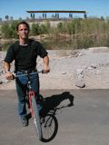
As
you may have seen elsewhere on my website, I rode
every Valley Metro bus route in South Phoenix for another class
project. With the extra time, I turned to another mode of transit:
my bicycle. I anticipated that riding my bike would let me cover
the entire open portion of the RSHRP during the allotted class
time. A slow leak made that a bit more challenging than expected.
Every bus in Phoenix is equipped with bicycle racks, although one
runs the risk the two slots will be occupied when the bus arrives.
I began my trek in the early morning light, catching the bus with
bike aboard.
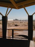
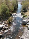
As
of this writing (March 2006), RSHRP is open to the public but still
under construction. It’s an interesting time, because if you really
squint, you can see the first manifestations of what is hoped for
from this effort. In some spots, however, a visitor would have to
nearly have her eyes closed to find this place attractive. I expect
appearances will improve in places such as at the far eastern end
(just past 16th Street) where construction is underway,
but the place is undeniably ugly near 19th Avenue.
Pedestrians or cyclists traversing the north bank there get squeezed
between chain link fences topped by barbed wire on a path sitting
astride a massive levee. For half a mile, the barren cap of an old
city dump stretches to the horizon, and abandoned gravel pits and
industrial uses hide behind the concrete-covered south levee. There
simply is too much to look past in order to take in the Sierra
Estrellas, South Mountain Park, or the downtown skyline. The levees
here are brutally honest, not masking themselves with vegetation and
setbacks simulating natural embankments as elsewhere in the RSHRP.
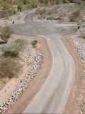
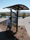
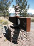
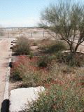
Such
sleight-of-hand has its greatest success near the Central Avenue
Gateway. Here there is relatively abundant vegetation and the
greatest intensity of amenities. The trails wind around marshes to
overlooks and weave their way past pump stations and other
accoutrements while sliding down into the river channel. The
numerous spots where visitors encounter smaller artificial streams
and pools of water go a long way to giving the RSHRP a human scale
feeling. Too much of it, however, leaves the visitor feeling lost
in a giant industrial scar. Folks studying urban ecosystems often
use phrases like “human dominated ecosystems.” The domination is in
your face here, and the notion of an ecosystem is merely a distant
strand of brush and puddles in the center channel. Even this
glimmer is absent, however, in most of the eastern reach where no
water flows. Great gulfs of barren rock seem all the more
uninviting in the mid-day glare. One feels very much the
interloper, not a guest. I will reserve judgment until completion,
but I suspect far fewer guests will linger in this eastern end as
around the Central Avenue hub.
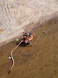
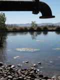
I
see this as a renovation and not a restoration for a couple
reasons. The most obvious are the massive levees. Storm sewers and
pumps supply what water that flows here outside those rare upstream
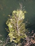
dam releases. Furthermore, several riparian ("of the river") ecological
zones are being
reintroduced in this short stretch of the river. In its natural
state, there likely would have been one with a few pockets. The
ever-present roar of jet engines is why the area nearest the airport
will remain far drier and free of vegetation by design. People feel
drawn to water, perhaps more so in desert cities. Installing a
continuum of riparian zones is a creative solution, however, to
concerns that birds not be attracted to the river and so become
potential hazards to planes arriving and departing Sky Harbor.
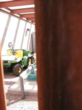
These musings hopefully leave you with a sense of my encounter with
the place as an individual, but hopes are high for this as a
communal space. I did encounter a few other wandering souls during
my trip. I ran into one gentleman “from the East Valley” in the
Gateway parking area. He had just stumbled across the RSHRP while
killing time before an appointment. Never having heard of it
beforehand, he thought the concept sounded interesting. A young
couple came to stroll along the pond to the overlook on their lunch
break. Both from South Phoenix, they felt the RSHRP eventually
would become an asset and a source of pride for the community. Also
near the Gateway but out on the trails, I ran across a preschool
group from the central city on a field trip. The adults, all women,
liked having a place to go walking that was isolated from traffic.
This separation from traffic also appealed to Gilbert. He biked the
trails as part of his daily work commute. I can only guess at how
much of his flying down the path was due to the trail dropping off
the levee top to go under Central Avenue and how much was the pull
of his waiting paycheck. Only after leaving the RSHRP did I realize
my conversations with the thirty or so construction workers were
limited to both parties nodding businesslike “hellos.” Given that
this ride fell mid-day on a weekday and just months after opening, I
was pleasantly surprised to meet a handful of people. This bodes
well for the project.