| Bio Freeze Frame Group Project Memory Maps Beyond the Banks Letter |
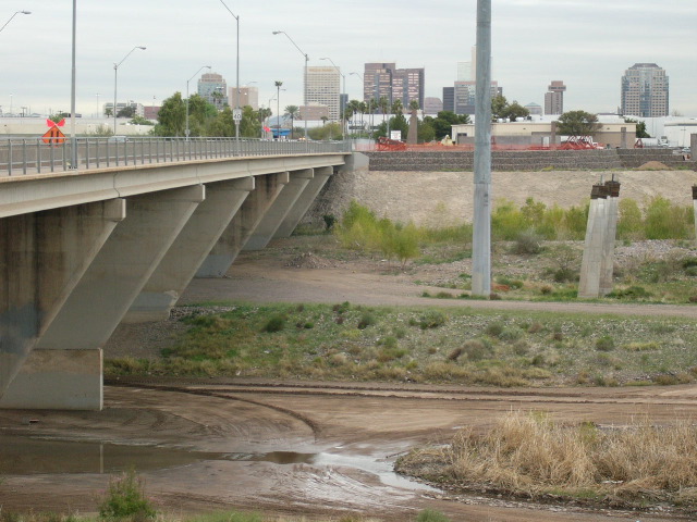
Rio Salado Beyond the Banks The Beyond the Banks plan is for the redevelopment of the area of South Phoenix bounded by the I-17 and I-10 freeways on the north, Broadway Road on the south, 19th Avenue to the west, and 32nd Street on the east. This project has been taken on by the City of Phoenix and the Army Corps of engineers.
Our group spent a great deal of time studying this area, and seeing it from many different perspectives. We have looked at gentrification and how it relates to this area. We have looked at turf markers, which are the personalizing items found in neighborhoods that make them unique, and studied how they are different from the old to the new subdivisions of housing found in South Phoenix. We have heard guest speakers on city planning and the difficulties they face daily trying to integrate the wishes of a community with the regulations of government and the realities of private developers. We have had guest speakers whose concern is toxic waste inequities in minority areas, and have voiced concerns on cleanup responsibility. The Rio Salado Beyond the Banks Area Plan is touched by each of these issues that we have addressed in class, and many that we are still unaware of. The purpose of the plan, as stated by the city of Phoenix, is to “maximize the city’s investment in the Rio Salado Project and revitalize the adjacent area with a desired mix of land uses”, it plans to do this by examining and including aspects of the area’s history and characteristics. It is a policy document that outlines goals for six areas of redevelopment interest. These are plans for land use, community recreation, economic development, neighborhoods, accessibility and safety.
Plans for land use include, but are not limited to, screening and also finding the funds to change non-conforming land uses. It also includes an enforcement of codes to alleviate the problems of inoperable vehicles, junk, litter and debris lying around. It will also require that outside storage is available and put in place regulations for the use of open and vacant buildings and structures. The land use goal also provides for the monitoring and targeting of specific areas for pit filling. These pits have come about by the use of mining in the area, and now are to be filled in to “ensure soil stability for future development” according the city’s five-year action plan. The community recreation aspect includes the addition of the Rio Salado scenic drive, which will be constructed on the north and south banks of Rio Salado. This will also require that new development takes this into account and is designed accordingly. The Rio Salado riparian area itself is a wonderful plan that includes the establishing of a riparian area, which is a wetland habitat, will attract some waterfowl and wildlife to the Rio Salado. There is the hope that with the reintroduction of native species of plants, the area will return to a similar environment that was found before the onset of heavy industrial and mining came to the area. There is a concern that birds being attracted to the riparian area here will pose a problem to the flight plan of Sky Harbor Airport. There are conflicting reports on the necessary safety zones for attracting birds. One report, found in the Environmental Justice Explorer entitled “The Rio Salado Project-The Rest of the Story”, states that according to the FAA, there should be a distance of “10,000 feet (about two miles)” between “wildlife attractants and the runway of airports serving commercial passenger jets.” It was found in our talk to (I can’t remember her name Dr. K) that they are working with the FAA and the airport and in so doing have made adjustments to the plan that involves allowing the area to gradually become drier the closer to the airport it comes. To augment this area, the city is already working on various walking and biking trails to run along the river, and there is also a plan in the works to add an Audobon Nature Center to promote learning in the community. Within the Community Recreation plan, there is also a vague promise to “work to increase youth-related recreational facilities and activities.” It will be interesting to see if this will involve more than just a YMCA, and if it will be targeted to all ages and ethnicities.
The plans for Economic development include attempts to bring in chain stores and businesses that will increase the prosperity of the area. This area at one time either had these types of chain stores and businesses and they moved out, or they were never there in the first place. This has caused the emergence of “predatory retailers”, which are those stores that charge inflated prices for their goods because of the lack of competition, according to Allen Stevenson of the city of Phoenix. With the appearance of chain stores on the scene, there is the hope that more competitive pricing will be found and this will alleviate this problem which can be particularly problematic for those in the lower income brackets. In the plan for the Neighborhoods, there is an estimated increase in the houses in the area from 7,700 to approximately 27,700 houses over the next twenty years. This increase in population is also going to help lure chain stores to the area, which in turn will attract more population. In addition to this, there is a plan, which has been discussed with and approved by the school district, to include the building of two additional public schools in order to meet the needs of the new residents. According to Susan Sargeant, with the City of Phoenix Planning Department, the reason that the public school increase does not appear to match the population increase is the availability of private and charter schools in the area. It does appear that there will be sufficient schools for everyone in the newly developed area. The only concern not addressed is the issue of whether or not there will be equal educational opportunities for all ethnicities found in the area. There is also a plan to add two new neighborhood parks, and the Del Rio Golf Course, which is to be located on a former park and landfill site south of the river between 8th and 15th streets. Accessibility to the area will be improved, and the burden of this will be placed on the incoming businesses, which will be required to improve the streets where there businesses will be found. This can include widening the streets and also landscaping enhancements. There will be some “new and upgraded infrastructure and streetscapes to enhance major access ways and corridors and provide the capability to support projected growth.” The final goal is Safety, the implementation of this plan includes an increase in police patrols “in neighborhoods and along the Rio Salado scenic drives to provide increase protection and a sense of security.” As this paper shows, there are consistently two sides to every situation. There appear to be some contradictions, such as the FAA requirements for the wetland areas, as one side tries to discredit the other or at the very least, as one side tries to make their plan more attractive to the community. This, as in the rest of the South Phoenix redevelopment plan, should be looked at from all angles. No matter what personal opinions are about the project, there are definite problems as well as some very good solutions and benefits apparent in this plan. There will obviously be those who suffer from its implementation, and there will be those that benefit. Because we live in a democratic and capitalist society, the greater majority will be heard, and there will be a leaning toward those with the greater number of dollars. Hopefully, the city planners will continue to take this into consideration and find the best way to maximize the benefits to everyone.
|
|
| Gaio Home Page | Contact: Vanesa Gaio(vanesa.gaio@asu.edu) | |